OL Fixbahn - Orientierungswandern & -laufen
Bad Tatzmannsdorf, Burgenland
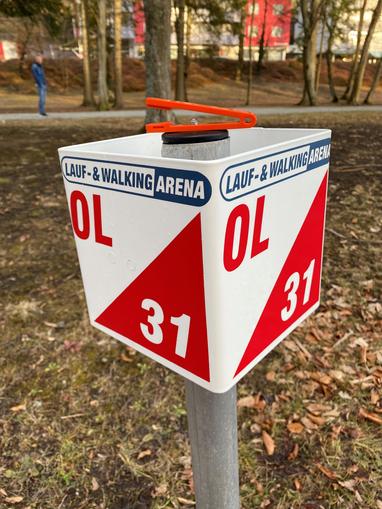
OL FIXBAHN with 18 posts in Bad Tatzmannsdorf. The permanent orienteering course is a challenge for everyone who doesn't want to run or hike along a predetermined path. The goal is to find individual posts with the help of a map and compass. The path between the posts is open and must be found using the map. The map is a detailed special map. Prominent points - such as paths, high seats, thickets, clearings and the like, which facilitate orientation, are marked. Before starting, the orienteer determines their location (adjust the map to the terrain = orient it north) and always maintains map contact along the way. They always know their position. What it's about: The orienteering hiker/runner must find marked points (=posts), which are drawn on the map, in the terrain with the help of a map (possibly also a compass). The path between the posts is open. The post - as shown - has a control number for confirmation that you are at the correct location, and pliers for marking in the control card. The sprint map is a special map and, in contrast to a normal hiking map, has a different scale and a much greater wealth of detail. Prominent objects such as paths, benches, streetlights, hedges, walls, stairs and the like, which facilitate orientation, are marked. For equipment, you only need sports shoes, running clothes, a map and possibly a compass. Map reading: At the start, you determine your own location and adjust the map to the terrain - you orient it north. Along the way, you always maintain map contact, i.e., you always know where you are. The post description is a more precise definition of the post location. e.g.: Post number 17 = fork in the path S Middle tree, S-side 11 Power line mast, SW-side 12 Hedge, NE-end 13 Transformer station, SW-corner 15 Cherry tree, NW-side 16 Walnut tree, N-side 17 Fork in the path 18 Fountain, NE-side 19 Flower bed, NW-edge 21 Beech, E-side 22 Southern spruce, NW-side 23 Southern vegetation boundary, N-corner 25 Thicket, NW-edge 29 Prominent tree, W-side 30 Hill, SW-foot 31 Gully bend 33 Bush, W-side 34 Statue, E-side 35 Hedge, NW-corner Start/Finish: Joseph Haydn-Platz Scale: 1 : 4,000 Equidistance: 2.5 m The OL-Fixbahn map is available free of charge at the Bad Tatzmannsdorf Tourism office.
Map & directions
Anzeige
Events nearby
Upcoming events within 10 km.


Experiences
Tours & activities in Burgenland
Guided tours, tickets and experiences in Burgenland — bookable via GetYourGuide.