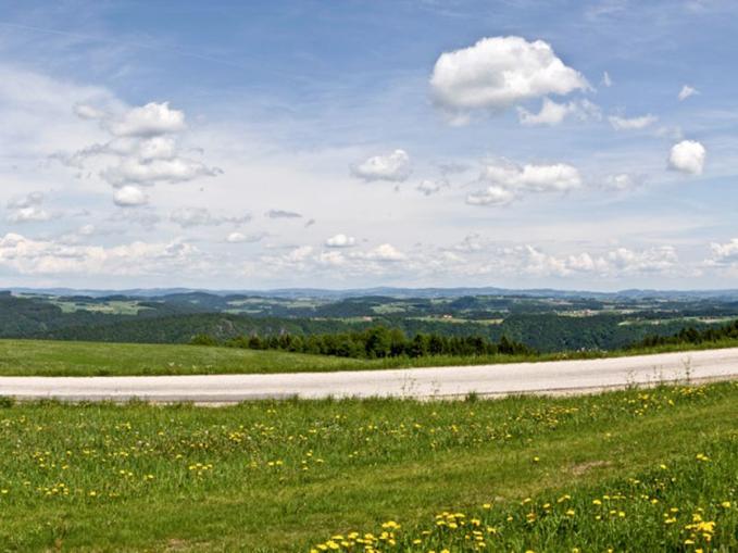
 Photo: WGD Tourismus GmbH
Panoramablick Paschinger Hügel | Sauwald Panoramastraße
Waldkirchen, Upper Austria
At 600 meters above sea level, the Paschinger Hügel (Pasching Hill) towers high above the Danube and offers fabulous distant views. The church steeples of 23 villages can be seen from this panoramic station, with the distant view reaching as far as Rohrbach, the transmitter on the Lichtenberg, and the Linzer Pöstlingberg. Surrounded by lush green meadows, the rest area in the village of Pasching, equipped with seating, invites visitors to stop and enjoy, while a telescope promises ever new views. From the second highest elevation in the municipality, you can see 23 villages and church steeples: Neukirchen am Walde / 5 km, St. Aegidi / 10 km, Untergriesbach (Lower Bavaria) / 21 km, Pühret (municipality of Neustift) / 11 km, Neustift / 13 km, Pfarrkirchen im Mühlkreis / 9 km, chapel in Lembach / 26 km, Niederkappel (Mühlviertler Dom) / 5 km, Rohrbach / 20 km, Haslach / 22 km, Arnreit / 16 km, Altenfelden / 14 km, Hollerberg church / 20 km, St. Anna-Steinbruck church / 17 km, St. Peter am Wimmberg / 20 km, Kirchberg ob der Donau / 7 km, St. Martin i.M. /15 km, St. Gotthard church / 22 km, Haibach ob der Donau / 6 km, Pöstlingberg near Linz / 33 km, radar station on the Kohlberg (Sauwald) / 12 km, transmitter on the Lichtenberg / 33 km, Stauff ruin (municipality of Haibach) / 9 km. The viewpoint and rest area were built by the Flixeder family and the municipality. A wooden observation tower that existed in the pre-war period until 1945 had to be dismantled due to age, and so the Flixeder family felt compelled to utilize this beautiful viewing area and erect a new panoramic aid. Through the sale of the Erledt No. 2 property, the area of the viewpoint and rest area was transferred to the successor/buyer Günther Kloimwieder and had to be dismantled on his property in 2013. Thankfully, the viewpoint or rest area could be rebuilt approximately 50 m next to the former site on the property of Leopold Kobler. Thanks to the landowner Leopold Kobler. Accessible via ....Linz - Eferding - Schlögener Schlinge - Wesenufer - Waldkirchen a.W. - Pasching Rohrbach - Altenfelden - Hofkirchen i.M. - Niederranna - Wesenufer - Waldkirchen a.W. - Pasching Passau - Engelhartszell - Wesenufer - Waldkirchen a.W. - Pasching Schärding - Münzkirchen - St.Roman - St.Aegidi - Waldkirchen - Pasching Ried - Riedau - St.Willibald - Natternbach - Neukirchen .a.W. - Waldkirchen a.W. - Pasching Wels - Grieskirchen - Waizenkirchen - St.Agatha - Pasching
Map & directions
Events nearby
Upcoming events within 10 km.

Experiences
Tours & activities in Oberösterreich
Guided tours, tickets and experiences in Oberösterreich — bookable via GetYourGuide.